


J-27/06- CARRAN LOOP WALK - 9,5 KM

jeanmarcMasson
Utilisateur GUIDE
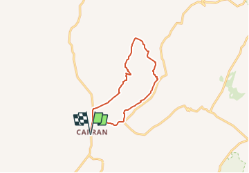

Longueur
9,6 km

Altitude max
238 m

Dénivelé positif
158 m
Km-Effort
11,7 km

Altitude min
112 m

Dénivelé négatif
158 m
Boucle
Oui
Date de création :
2024-05-28 15:05:23.533
Dernière modification :
2024-05-28 15:10:04.585
2h39
Difficulté : Moyen

Application GPS de randonnée GRATUITE
 SityTrail
IGN / Instituts géographiques
SityTrail Plus
Le monde est à vous
À propos
Randonnée Marche de 9,6 km à découvrir à Inconnu, County Clare, West Clare Municipal District. Cette randonnée est proposée par jeanmarcMasson.
Localisation
Pays :
Irlande
Région :
Inconnu
Département/Province :
County Clare
Commune :
West Clare Municipal District
Localité :
Carran ED
Départ:(Dec)
Départ:(UTM)
494861 ; 5876163 (29U) N.
Commentaires